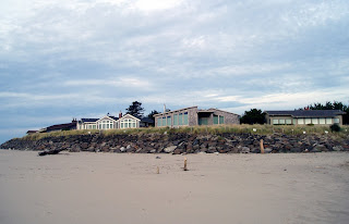
Our first stop on the Coast was Lincoln at Devil’s Lake
State Park. Only the north section was open due to the rain, the south was
flooded out. Actually there was quite a bit of water in our row too. After one
rainy night, the end of our site was a giant puddle!
The State Parks in Oregon are manned by welcoming volunteers
who answer questions, give interesting tips on the area, clean, trim hedges,
grass and bushes, pick up litter and generally keep the parks in excellent
condition. It was not unusual for there to be 2 or even 3 hosts in a park, so
we could always find one to talk with. We ended up staying in State Parks all
down the coast, paying $20 to $23 per night, always with electric and water,
and in many places with cable and sewer. There was no wifi at any of the Parks,
but we always managed to find a coffee shop, or McDonalds, so we were fine.
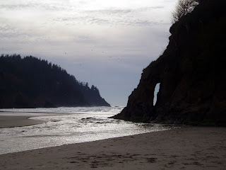
The first morning in Lincoln, we walked along the beautiful
beach, with the surf pounding on the shore.
 |
| Lincoln Beach |
I just stood looking in wonder at
the long sandy beach with the surf snaking along the shoreline.
 |
| As we walked South, it became foggy |
 |
| Long Sandy Beach |
Lincoln also
boasts the world’s shortest river, D, from
Devil’s Lake to the Ocean,
and the only Tangers Outlet Mall on the Oregon
Coast. John is not much of a shopper, but he tagged along and even wandered
into a couple of stores and bought a pair of shoes.
The folks at the “i”s, Visitor Information Centres, were really helpful with maps, and
suggestions of local points of interest or good coffee shops or cafes.
Using Lincoln as our first coastal base, one day we drove
north to find a hiking trail that had been recommended. We couldn’t find it,
but did have lunch in a delightful cafe in Neskowin, and walked along the beautiful
beach behind it.
.JPG) |
| Neskowin Beach |
 |
| ...to the North |
On the way back we checked email at McDonalds, and decided to
check out the Casino, and to have the buffet –full meal for $14.99 each, and,
because it was Oregon, no tax. The Casino also has a large paved parking area
for RV’s to park overnight.
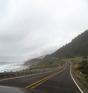
Another day we drove south along Otter Road, off 101, to Boiler Bay
where
a small freighter sank in 1910, [the boiler can still be seen at low tide],
Depoe Bay, a small community with the world’s smallest navigable harbour and Cape
Foulweather, named by Captain James Cook,
.JPG) |
| Cape Foulweather |
.JPG) |
| South from Cape Foulweather |
and the Devil’s Punchbowl,
 |
| Devil`s Punchbowl- we didn`t walk down, just took pictures |
a basalt
formation with fascinating wave action. The coast is beautiful, rugged in
places with cliffs and trees right to the crashing surf, and miles of sandy
beaches with rolling surf in others. No part of the shore, beach or rocky
crags, can be private. A former Governor of Oregon ensured that the public has
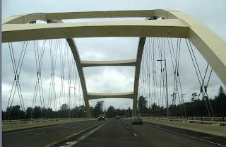
access to any beach or tidal pool right along the Oregon shore. The Bridge at
Depoe Bay, originally built in 1927 and doubled in size on the seaward side in
1940, is an excellent example of Conde McCullough’s engineering and artistic
design.
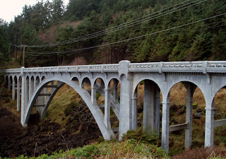 |
| A McCullough bridge at Depoe Bay |
It was time to head down the coast to Carl G. Washburne
Memorial State Park between Yachats [pronounced YAH-hats] and Florence. We had a beautiful, clear
50 ft site, beside a trail to the beach.
 |
| Our site- private, quiet and no leaves |
 |
| Another beautiful, private site |
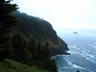
It was a short drive north to Yachats
and Newport, or south to Florence. On the drive north to Yachats, 800 feet
above the ocean, is Cape Perpetua, named by Captain James Cook. The road hugs
the side of the cliff, as it winds up to about 400 ft and then down again. I
was forewarned, but couldn’t look as we went around the curves, with me on the
outside of the vertical cliff.
.JPG) |
| Looking North to Cape Perpetua from the View Point |
 |
| Looking South from Cape Perpetua |
The first morning, we walked the trail to the
beach. It was like an enchanted forest, eerily shaped, leafless trees, with
moss on the trunks and branches, going through bushes,
 |
| My Enchanted Forest walk to the beach |
through rocks, then onto
another spectacular beach.
 |
| Carl G. Washburn Memorial State Park Beach |
Later we drove south to see the coast and the Sea
Lion Caves. They have a remote video feed to the Caves, but the sea lions were
out playing in the surf. However, the owners gave us a ‘deal’ on admission, so
we decided to see it. The cave is a naturally formed underground cavern,
accessed by an elevator, down 200ft. From one side you can see into the Sea
Lions’ Cave
 |
| The Sea Lion Cave minus the Sea Lions |
and from the other you can see across the cove to the Heceta Head
Lighthouse.
 |
| Heceta Lighthouse from The Sea Lion Cave |
There are informative displays, and artifacts, even skeletons of
the sea lion.
We tried several seafood restaurants. In Yachats,
 |
| Driving into Yachats |
we had a seafood
lunch and then excellent coffee [and wifi] at the Green Salmon,
 |
| Wifi, excellent lattes and excellent food- what`s not to like! |
in historic
downtown Florence, we went to Mo’s, right on the wharf. Their seafood bouillabaisse
was excellent. It was so good, that later we went back for lunch-seafood
sliders and the best oyster stew. One day, as we used the wifi, we had lunch
at the Green Salmon-excellent wrap and huge Caesar salad - then drove around the
interesting homes in Waldport on the Alsea Peninsula and Smelts Beach- a
favourite spot for finding agates.
 |
| Driving north to Yachats- I am on the inside! |
 |
| Smelts Beach - looking for Agates |
 |
| Smelts Beach - tide pools |
We could find places to drive to, even in
the drizzle and fog.
Since we hadn’t really seen Cook’s Chasm geyser blowhole in
action, and the surf was quite high, we tried again and were rewarded with some
awesome blowhole geysers.
 |
| Cook’s Geyser |
 |
| Looking North from the Geyser |
Then we drove to the top of Cape Perpetua- all 802
feet of it- up a narrow, winding road. The view is spectacular.
 |
| Looking 802 feet down |
The Aquarium in Newport was fun, even in the rain. Otters, grey
Harbour seals, sleek California Sea Lions and a variety of ducks and birds were
in outside enclosures,
 |
| Sea Lion being fed |
 |
| Playful Seals |
and inside, in creative and interesting tanks, were a many
types of fish, from anchovies to dogfish and a small shark. The pathway was a
tunnel with fish swimming on either side of you, over your head and under your
feet.
In another section were tanks of anemones, jellyfish
and other sea
critters. One indoor section was set up as hands-on. Visitors could touch a
variety of starfish, mollusks and sea anemones.
We found another quirky, delightful coffeehouse in Florence,
with displays of local Art and jewellery, and pottery.
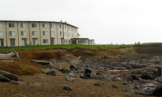
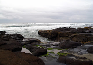
Our next stop in Oregon was at Bullards’ Beach Campground in
Bandon. The sites are beautiful, and required no levelling at all. The Beach is
a few miles from the campground, so we drove down, walked for a bit along the
beach and around the lighthouse,
and into Bandon to see the old town.
 |
| Another McCullough Bridge into Bandon |
Since it
was Sunday, not too much was open.
 |
| A Critter made from refuse collected on the beaches |
 |
| ``Cat and Kittens`` rock `stacks` in Bandon |
 |
| Face Rock in Bandon |
It rained all that night and for the next couple
of days. The first day, we drove to the beach to check out the high tides and
surf, then went into Bandon, found a Fish Shop to have lunch and to the Bandon
Coffee Cafe for wifi and lattes. The second day of rain, we drove up to Coos
along a back road, and found a unique Deli to have lunch and use wifi. By this
time, I was getting a little tired of the dreariness, but was told by the owner
of the Deli, that this was the weather for the next couple of months.
The next
day, however, we woke to beautiful sun. There were a couple of other Airstreams
in the Park while we were there. One of the most interesting aspects of this
lifestyle is the people you meet. We have been getting great tips from other
travelers, about where to go, where to camp, and how to get there, and areas of
the coast to avoid with the Airstream.
Off we headed, south again- looking for warmth and sun.
There was a hard frost on the ground the last night, and ice on the puddles.
The coast continued to amaze me- rugged coast with rocks rising out of the ocean,
sandy beaches for miles, and half-moon sandy coves nestled in the rocks at low
tide.
 |
| Gold Coast shoreline |
 |
| Long sandy beaches... |
 |
| as far as the eye can see... |
 |
| Rocks rising out of the ocean... |
 |
| sandy coves... |
One section of Hwy 1, has 2 lanes raised several meters above bogs,
with dunes on one side and the ocean, and mountains on the other side. We
arrived at Harris State Park, in Brookings.
.JPG) |
| Our site at Harris State Park |
 |
| Harris State Park beach- a bird sanctuary |
 |
| Another view of the Beach |
.JPG) |
| Sunset in Brookings at Harris Beach |
We found out why this is such a unique
section of the Pacific coast. They call it “The Banana Belt”. It is always
warmer here than any place else, even San Fransisco. The TV Weather Forecaster [on
our cable network] kept talking about the “Brookings Effect”. We had
temperatures in the 70’s while the rest of the coast was in the low 60’s. We
were in TShirts, and loving it. We did a bit of shopping, tried wifi in Fred
Myers, [but the Mac won’t work in some places, so John went to McDonalds]. We
had talked to a camper who had just come up the coast from California, and
loaned us a couple of excellent books. Since we were just north of the
California Border, we decided to get some information at Crescent City on the
redwoods and camping. We stopped in at the California State Redwood Parks, and
got information on state parks, and the Redwoods, but not general camping
information. So we drove up to the redwoods in Jedediah Smith Redwoods State Park. They
are amazing.
.JPG)
We were on a one lane road with lots of pull-outs so cars could pass
each other. The trees are magnificent-tall, straight, huge.
 |
| The truck and I are dwarfed... |
 |
| ...and it is golf-shirt weather |
We stopped many
times. Every time we went around a bend there would be more, taller and wider,
with very little underbrush. There was a trail, which we later learned was the
“Boy Scout Trail’, easy walking with wood chips on the path, which wove its way
through these ancient trees. We could only walk for an hour as it was getting
late, and darkness came by 5pm.
John in his wanders, met a couple of young men in the
“Hiker/Biker section of the Park, who had come in the night before, but had
their bikes and some of their gear stolen overnight. They came over for a few
drinks after supper. They had become friends at university, and were biking
from Vancouver to San Francisco. After talking for several hours, it was
decided that we would take them to the redwood forest the next day. Otherwise
they would miss it completely because they had decided to hitchhike to San
Francisco, and fly home from there. On our way through Crescent City, we
stopped at the California “i”, and got some excellent maps
and information. The volunteer suggested
we stop at the Harbour, since there were usually sea lions there. WOW, there
certainly were. We heard them long before we saw them.
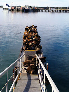.JPG) |
| Crescent City Harbour with the California Seals enjoying the weather |
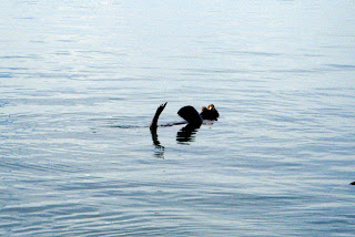.JPG) |
| Look Mum, I can Float! |
Then, we took the same road through the redwoods,
but went on a different trail- just as spectacular.
.JPG) |
| Magnificent! |
Their reaction was similar
to ours - awe.
 |
| John did a bit of climbing too |
But they were much more agile, and were soon scrambling on
fallen logs and cross-cuts by the path.
 |
| This is the biggest tree... |
So, our time on the Oregon Coast ends. Next on to
California, missing the first section of the coast, but travelling inland along
Hwy 101, and more Redwoods!


.JPG)

.JPG)
.JPG)


.JPG)


.JPG)

.JPG)


.JPG)


.JPG)


.JPG)
.JPG)
.JPG)
.JPG)


.JPG)
.JPG)
.JPG)

.JPG)
.JPG)
.JPG)
.JPG)


No comments:
Post a Comment